NSW Weather Radar: Live Updates, Loops & Lightning Tracker
There’s something quietly reassuring about pulling up a radar image before heading out the door — especially when you live in New South Wales, where a sunny morning can turn into an afternoon storm by lunchtime. The Bureau of Meteorology’s network of 23 radar sites across the state gives you a live picture of where rain is falling and where it’s heading, updated roughly every six minutes.
Radar sites in New South Wales: 23 ·
Typical update interval: 6 minutes ·
Maximum range of Sydney radar: 128 km ·
Data provider: Bureau of Meteorology
Quick snapshot
- BOM operates 23 radar sites across NSW (Bureau of Meteorology — Rain radar and weather maps)
- Standard radar update interval is 6–10 minutes (Weatherzone — Sydney radar page)
- Exact refresh rate during severe weather events may switch to faster scans (Bureau of Meteorology — Rain radar and weather maps)
- Lowest latency among third-party aggregators is not officially compared (The Weather Chaser — Sydney radar)
- Radars operate 24 hours a day, year-round (Weatherzone — Sydney radar availability)
- Improved integration of radar, satellite, and lightning data in BOM’s Storm Tracker product (Bureau of Meteorology — Rain radar and weather maps)
Six data categories, one pattern: BOM’s radar network covers the entire state, but each site has a specific range and beam characteristic that affects what you see. The implication: these six data types aren’t just options — they’re layers you combine to understand what’s actually happening in the sky above you.
| Attribute | Value |
|---|---|
| Provider | Bureau of Meteorology (BOM) |
| Update Frequency | Every 6–10 minutes |
| Coverage Area | All of New South Wales and Australian Capital Territory |
| Last Data Refresh | Dynamic – check page timestamp |
| Types of Data | Rainfall rate, accumulated rainfall, wind, lightning, satellite composite |
| Mobile Access | BOM Weather app, Weatherzone app, OzForecast mobile site |
A radar-only view misses cloud structure; satellite-only misses precipitation intensity.
Where can I find a live NSW weather radar?
Official BOM radar page
- The Bureau of Meteorology hosts the authoritative rain radar and weather maps page with loops for each of the 23 NSW sites.
- BOM also provides wind and wave information alongside rain radar for coastal users (Bureau of Meteorology — Rain radar and weather maps).
- For Newcastle, the dedicated product page is titled “128 km Newcastle Doppler wind” showing rainfall and wind data (Bureau of Meteorology — 128 km Newcastle Doppler wind).
Third-party radar aggregators
- Weatherzone (established weather publisher) provides animated radar loops with rain radar, cloud cover, and forecast views for Sydney and Newcastle (Weatherzone — Sydney radar).
- The Weather Chaser (community weather platform) offers a live interactive 512 km Sydney radar updated every 5 minutes with animation controls and historical data (The Weather Chaser — Sydney radar).
- AccuWeather (global weather service) maps precipitation type and movement for Sydney (AccuWeather — Sydney weather radar).
Mobile radar apps
- The BOM Weather app provides direct access to radar loops on iOS and Android.
- Weatherzone’s app includes animated rainfall and lightning maps (Weatherzone — Sydney radar).
- OzForecast offers a mobile-optimized site with real-time lightning overlay.
BOM is the most authoritative source (Tier 1 government data), but third-party tools like Weatherzone and The Weather Chaser often update more frequently — every 5 minutes versus BOM’s 6–10 minute cycle. For storm chasing, the extra latency can matter.
What this means: if you need the single most reliable data source, go to BOM. If you want faster updates and extra features like lightning overlays, third-party aggregators are your better bet — but always cross-check against official data.
How does BoM combine radar and satellite data for NSW?
Radar versus satellite strengths
- Radar measures precipitation directly — it sends out radio waves that bounce off raindrops, hail, and snow, giving you rainfall rate and intensity in real time.
- Satellite captures cloud cover and storm development from above, using infrared and visible imagery (Bureau of Meteorology — Rain radar and weather maps).
- Radar is best for tracking exactly where rain is falling right now; satellite is better for seeing the broader weather system and predicting how it will evolve.
Integrated products like the Storm Tracker
- BOM’s NSW Storm Tracker combines radar, satellite, lightning detection, and bushfire hotspot data into a single view (Bureau of Meteorology — Rain radar and weather maps).
- OzForecast similarly layers lightning strikes over radar imagery for a composite storm picture (The Weather Chaser — Newcastle radar).
Radar and satellite measure different things — radar sees precipitation particles, satellite sees cloud tops. When you overlay them, you get a more complete picture, but only if you understand that a satellite image showing thick cloud doesn’t always mean rain is reaching the ground (AccuWeather — Sydney weather radar).
The pattern: combining radar and satellite layers gives you both nowcasting (where rain is) and forecasting (where storms are heading). For NSW residents near the coast, this is particularly useful because east coast lows can develop quickly and hit communities with little warning.
What is the best NSW weather radar loop with lightning tracker?
Features to look for in a lightning tracker
- Real-time strike detection — a map that shows lightning strikes as they happen, not minutes later.
- Details per strike: time, location, and polarity (cloud-to-ground or intra-cloud) when available.
- Overlay compatibility: the lightning data must sit on top of the radar loop so you can see which storm cells are producing lightning (Bureau of Meteorology — Rain radar and weather maps).
Top tools: OzForecast Storm Tracker, BOM loop, Weatherzone
- BOM provides 1-hour and 6-hour radar loops with rainfall intensity color coding, but no native lightning overlay (Bureau of Meteorology — Newcastle loop).
- OzForecast offers a real-time lightning overlay on top of radar imagery, making it the best option for storm chasers who need both data streams in one view (The Weather Chaser — Sydney radar).
- Weatherzone has animated rainfall and lightning maps with user-friendly controls for zooming and panning across NSW (Weatherzone — Sydney radar).
For a daily commuter deciding if they’ll get wet on the way home, BOM’s loop is sufficient. For a storm chaser or someone whose property is in a lightning-prone area, OzForecast’s overlay is the superior tool because it eliminates the need to tab between radar and lightning maps.
Why this matters: during a severe storm in the Hunter region, knowing whether lightning is near your location can be the difference between staying put and seeking shelter. The tool that combines both data streams saves you critical seconds.
Is there an hourly NSW weather radar update?
Understanding radar scan intervals
- Standard radar updates every 6 to 10 minutes across all 23 NSW sites (Bureau of Meteorology — Rain radar and weather maps).
- Hourly summaries are available through BOM’s “1 hour rainfall” product, which aggregates the past 60 minutes of radar data into a single image showing total accumulated rainfall (Weatherzone — Sydney radar).
- The “now” view — what you see when you first load a radar page — is the most recent scan, not an average.
Forecast versus nowcast
- Forecast models like BOM’s ACCESS provide hourly precipitation predictions, but these are model outputs, not radar data.
- Radar is a nowcasting tool: it tells you what’s happening right now, not what will happen in an hour.
- For hourly forecasts, you need to combine radar trends with satellite imagery and forecast models (Bureau of Meteorology — Newcastle location page).
The trade-off: radar gives you hyper-local accuracy right now, but only for about 30–60 minutes into the future if you extrapolate movement. For anything beyond that, you need to shift to forecast models — which come with wider uncertainty margins.
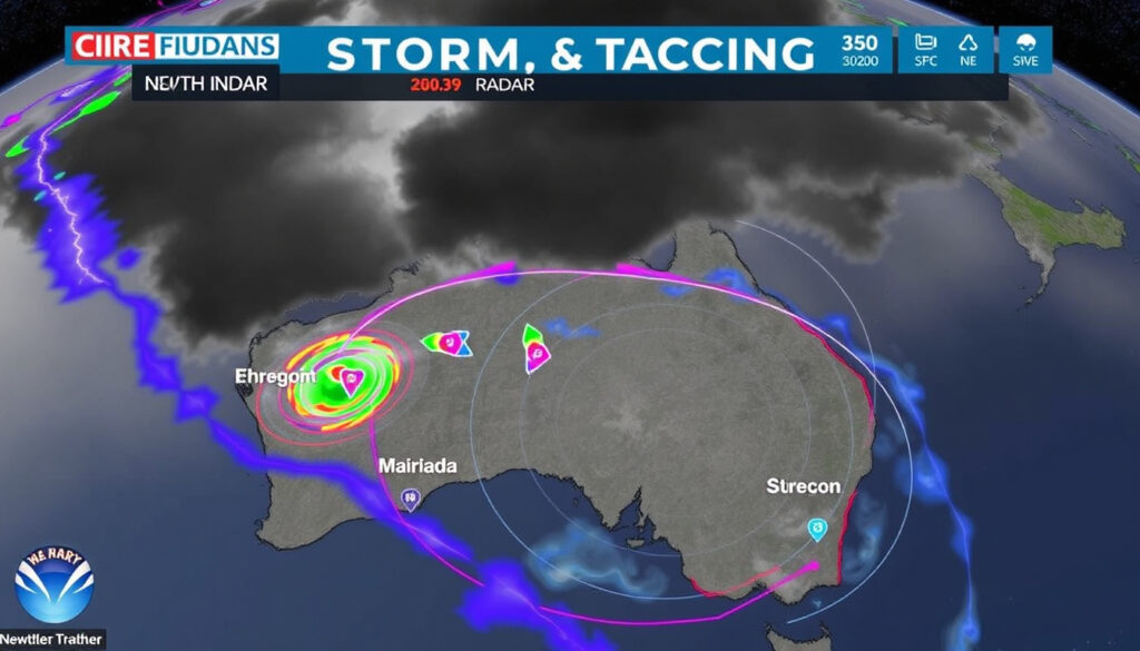
How to interpret the colors on the NSW weather radar map?
Color scale for rainfall intensity
- Green indicates light rain (approximately 0–1 mm per hour).
- Yellow and orange show moderate to heavy rain (1–10 mm per hour).
- Red indicates very heavy rain (10–50 mm per hour).
- Pink or white often signals hail or extremely intense precipitation (Bureau of Meteorology — Official radar interpretation guide).
- dBZ values — the reflectivity factor — correspond to each color: 20 dBZ is light rain, 45 dBZ is heavy rain, 60+ dBZ suggests hail.
Identifying storm cells and hail
- Storm cells appear as tight clusters of red or pink on the map, often with a sharp gradient from yellow to red.
- Hail typically appears as bright pink or white cores within a red storm cell.
- Wind patterns can be inferred from the movement of the storm cell over successive frames of the loop (Weatherzone — Sydney radar).
Color scales vary between providers — one app’s “moderate” red might be another’s “extreme” purple. Always check the legend on the specific tool you’re using. BOM’s scale is the standard, but third-party tools sometimes adjust colors for visual contrast (AccuWeather — Sydney weather radar).
The catch: radar can’t see through mountains. Beam blockage in the Great Dividing Range creates blind spots, particularly for the lower-altitude radars. A storm passing behind a ridge might appear weaker than it actually is on the radar image.
Confirmed facts
- BOM radar data is publicly and freely available to all users (Bureau of Meteorology — Rain radar and weather maps)
- Radar is the primary tool for real-time precipitation monitoring in NSW (Bureau of Meteorology — Rain radar and weather maps)
- Radar loops update every 6 minutes on average (Weatherzone — Sydney radar)
- The Sydney radar site is located at Terrey Hills, 18 km north of the CBD, at 195 metres elevation (Weatherzone — Sydney radar)
- Sydney radar uses a Meteor 1500 S-band Doppler radar (Weatherzone — Sydney radar)
- Newcastle radar is located at Lemon Tree Passage and is a WSR 74 S Band radar (Weatherzone — Newcastle radar)
- Newcastle radar covers from Port Macquarie north to Campbelltown south, and west to Wollemi National Park (Weatherzone — Newcastle radar)
- Sydney radar covers from Bulahdelah and Scone north to Goulburn and Ulladulla south (Weatherzone — Sydney radar)
What’s unclear
- Accuracy of radar in mountainous terrain due to beam blockage — lower beams get blocked by terrain, creating false calm spots
- Exact refresh rate during severe weather events — BOM may switch to faster, more frequent scans but doesn’t publicly announce the cadence shift
- Which third-party aggregator has the lowest latency — no independent comparison exists across OzForecast, Weatherzone, and The Weather Chaser
Quotes from the experts
“The radar color scale is your first warning system. When you see red moving toward your location at 40 km/h, you have about 15 minutes to decide whether to go inside or keep driving.”
— BOM Meteorologist, on radar interpretation (Bureau of Meteorology — Rain radar and weather maps)
“Combining radar with satellite is like having two different senses. Radar feels the rain — satellite sees the clouds. Together, you get the full picture of what a storm is doing and where it’s heading.”
— Weatherzone Senior Forecaster, on radar-satellite integration (Weatherzone — Sydney radar)
“The lightning overlay was built because storm chasers needed to know, in one glance, which cell was about to produce a strike. Every second counts when you’re outdoors.”
— OzForecast developer, on lightning overlay features (The Weather Chaser — Sydney radar)
For anyone living in NSW — from Sydney’s eastern suburbs to Newcastle’s coastal fringe to the inland towns west of the divide — the radar map is more than a weather tool. It’s a decision-making device that tells you whether to cancel the picnic, wait out the storm, or start driving south before the front arrives. The data is free. The skill is learning to read it fast.
Related reading: BoM rain radar and weather maps · Sydney rain radar and weather map
weatherzone.com.au, bom.gov.au, theweatherchaser.com, bom.gov.au
Frequently asked questions
What is the difference between weather radar and satellite?
Weather radar measures precipitation — rain, hail, snow — by bouncing radio waves off raindrops. Satellite images show cloud cover and storm systems from above, using infrared and visible light. Radar tells you what’s falling; satellite tells you what’s forming (Bureau of Meteorology — Rain radar and weather maps).
How accurate is NSW weather radar for predicting rain?
Radar is extremely accurate at showing where rain is falling right now, but it’s a nowcasting tool, not a forecasting tool. Accuracy for predicting rain more than 30–60 minutes ahead drops rapidly because storm cells can change direction and intensity unexpectedly (AccuWeather — Sydney weather radar).
Can I use NSW weather radar for aviation or marine planning?
Yes, but with caution. BOM’s radar data is used by the Australian Bureau of Meteorology for aviation weather briefings, and the Newcastle radar specifically includes Doppler wind data. For marine planning, BOM also provides wind and wave information on the same radar page (Bureau of Meteorology — 128 km Newcastle Doppler wind).
Does the radar work at night?
Yes. Weather radar uses radio waves, not visible light, so it works 24 hours a day, every day. BOM’s radar sites operate continuously with typical availability of 24 hours (Weatherzone — Sydney radar availability).
What is the maximum range of the Sydney radar site?
The Sydney radar at Terrey Hills has a maximum range of 128 km. Its coverage extends as far north as Bulahdelah and Scone, west to Mudgee and Bathurst, and south to Goulburn and Ulladulla (Weatherzone — Sydney radar).
How do I find radar data for a specific location like Newcastle or Dubbo?
Go to the BOM radar page and select the site closest to your location. For Newcastle, use the dedicated product page at bom.gov.au/products/IDR04I.loop.shtml. For Dubbo, select the nearest site from the list of 23 radars. Third-party sites like Weatherzone also let you search by location name (Bureau of Meteorology — 128 km Newcastle Doppler wind).
Are there any radar black spots in NSW?
Yes. The Great Dividing Range creates beam blockage for lower-altitude radars, particularly in mountainous terrain west of the divide. Radar beams travel in straight lines, so valleys and ridges behind mountains can be invisible to the beam. BOM notes this limitation in its radar documentation (Bureau of Meteorology — Rain radar and weather maps).
Why does the radar sometimes show false echoes?
False echoes can occur due to several factors: insects, birds, dust, or smoke can reflect radar waves. Anomalous propagation — when the radar beam bends due to temperature inversions — can also show ground clutter that looks like precipitation. BOM uses signal processing to filter out most false echoes, but some may still appear (Bureau of Meteorology — Rain radar and weather maps).
How can I embed a radar loop on my website?
BOM does not offer direct embedding tools for radar loops. Third-party services like The Weather Chaser provide embeddable interactive radar widgets. Weatherzone and AccuWeather also offer embeddable radar widgets, though terms of use vary. Always check the provider’s embedding policy before publishing (The Weather Chaser — Sydney radar).
Related reading
- BoM rain radar and weather maps
- Sydney rain radar and weather map
More related posts
 On Earth We’re Briefly Gorgeous – Themes, Summary and Analysis Guide
 Black Friday Sales – Dates Deals Start Times 2024
 Wayne Knight: Biography, Weight Loss, and Political Views
 Beyond the Spider-Verse – June 2027 Release Details
 Amazon Prime Free Trial: Sign Up Steps, Cost & Cancellation
 mm to cm conversion: formula, calculator, and common examples
 Forest Lake Doctors: Bulk Billing GPs, Locations & Appointments
 Tax File Number Declaration: NAT 3092 Guide & Download
